[Poland]Vertical Mapper
 Print this page
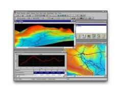
Vertical Mapper works seamlessly with MapInfo Professional to display your data in a continuous surface - a grid - with data representations at any given cell on the surface. Use Vertical Mapper to visualize elevation, see the crossection, analyze point-to-point visibility or create a viewshade.
Additional information:
Related products: Computer Hardware & Software ->Software
| |
|
|
| |
IMAGIS S.A.
|
| Street: | Górczewska 212/226 |
| City: | Warszawa |
| Postal code: | 01-460 |
| Region: | Mazovia |
| Country: | Poland |
| Phone: | +48 22 6384186 |
|
Contact person |
| Name and Surname: | Łukasz Brzostek |
| Phone: | +48 22 638 41 86 |
|
|
| |
|
|
 E-mail this Product to friend

 Add this Product to Basket


